16443 W Sala Lane, Hauser, ID 83854
Local realty services provided by:CENTURY 21 Beutler & Associates
16443 W Sala Lane,Hauser, ID 83854
$995,000
- 18.23 Acres
- Lots / Land
- Active
Listed by:
 Sarah Scott(208) 301 - 0510CENTURY 21 Beutler & Associates
MLS#:25-2917
Source:ID_CDAR
Price summary
- Price:$995,000
About this home
Hauser Lake view from 10-20 acres, & SELLER FINANCING OPTIONS. 40x60 red iron shop. All infrastructure & site prep. completed: h the shop & build pad: WELL WATER- SEPTIC- POWER (400 amp) - Building pa. NO HOA, CC&R's, or City fees. Both the shop & build pad have utilities, 30 & 50 amp electric. Built in Nov. 2023, the red iron beam shop has a ~10x10 bath/ laundry room framed & plumbed & a 16x14 roll-up door. Enjoy all the benefits of rural living with proximity to city amenities: mail delivery, garbage pickup, <1/4 mile to the Lake & dining, a few miles to Post Falls, 5-miles to I-90, 6-miles to Organic groceries, 10 miles to Cd'A, 12 miles to Spokane Valley. Adjacent acres available on the west boundary, to make a 20 acre homestead, or buy 10 acres and a lot line adjustment can be discussed. Mapping Applications (APPs) such as 'OnX Hunt' are a tool to help find approximate property boundaries while on site.
PROPERTY BOUNDARY NOTES:
1) The SOUTHWEST corner survey pin is located left of the 16433 driveway entrance; flagged; signs denote the location.
>From this pin, the SOUTH property boundary is uphill to the right.
>From this pin (along the dirt road to the left) is the southern portion of the WEST property boundary; uphill; marked with signs and flagging.
2) The NORTHWEST corner survey pin is located uphill on the left side of the build pad site, marked with blue & pink tape, approximately 50' into the trees; a sign denotes the location.
> From this pin, the NORTH property boundary runs to the right & uphill with intermittent stakes flagging the approximate property line.
> From this pin, the northern half of the WEST property boundary is viewed adjacent to the build pad and shop, marked with signs & flagging.
> Adjoining acreage available (from a neighbor) along this northern-west property boundary, to own the visible land, & widen the property if desired.
> From the build pad site, a dirt road located east of the driveway, leads to the SOUTH EAST property boundary & driveway to 16431.
3) The EAST property boundary can be viewed from the top of the 16431. Permission to drive through to view needed.
BUILD PAD UTILITIES:
> Electric panel at the corner near driveway. 200 amp electric with 30 & 50 amp plug ins.
> Septic connection (covered by an orange cone) located in front of the electrical panel.
> Water on/off valve is below ground. Access is capped with black ABS pipe, located in front of the electrical panel & to the right of the Frost-Free hose connection....
Contact an agent
Home facts
- Listing ID #:25-2917
- Added:358 day(s) ago
- Updated:March 15, 2026 at 02:51 PM
Rooms and interior
- Living area:2,400 sq. ft.
Structure and exterior
- Building area:2,400 sq. ft.
- Lot area:18.23 Acres
- Lot Features:Wooded
Utilities
- Water:Shared Well
Finances and disclosures
- Price:$995,000
- Tax amount:$2,340 (2024)
New listings near 16443 W Sala Lane
 $1,950,000Active5 beds 4 baths4,608 sq. ft.
18059 N Advent Ln, Hauser, ID 83854
MLS# 26-2049Listed by: PEARL REALTY, LLC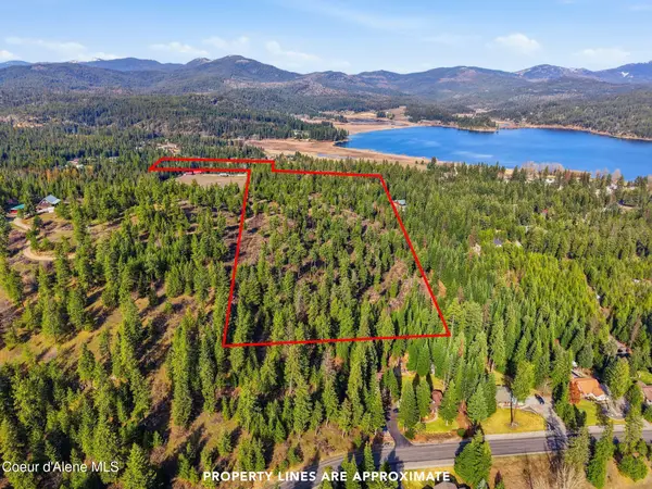 $1,550,000Pending34.14 Acres
NKA Hildesheim Ln, Hauser, ID 83854
MLS# 26-1978Listed by: KELLER WILLIAMS SPOKANE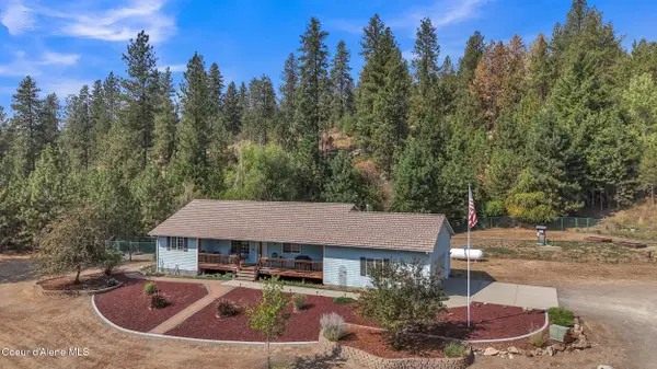
 $875,000Pending4 beds 3 baths2,588 sq. ft.
8057 N Vogt Rd, Hauser, ID 83854
MLS# 26-1980Listed by: CENTURY 21 BEUTLER & ASSOCIATES $215,000Active3 beds 2 baths1,782 sq. ft.
8553 N Kendra WAY, Post Falls, ID 83854
MLS# 26-1975Listed by: WINDERMERE/COEUR D'ALENE REALTY INC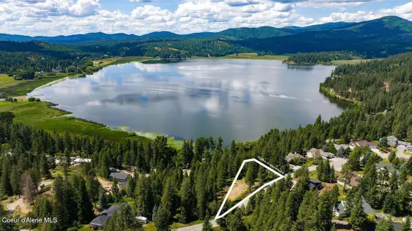 $260,000Active1.32 Acres
NKA W Woodlake Dr, Hauser, ID 83854
MLS# 26-1820Listed by: EXP REALTY $1,199,000Active3 beds 2 baths1,782 sq. ft.
10824 N Payment Peak Rd, Hauser, ID 83854
MLS# 26-1607Listed by: EXP REALTY $1,500,000Active19.18 Acres
10176 N Cliff House RD, Hauser, ID 83854
MLS# 26-1311Listed by: NAI BLACK $149,950Pending2 beds 2 baths1,296 sq. ft.
17580 W Santiago CIR, Post Falls, ID 83854
MLS# 26-1212Listed by: PROFESSIONAL REALTY SERVICES IDAHO $629,900Active4 beds 2 baths1,914 sq. ft.
17783 W Rice AVE, Hauser, ID 83854
MLS# 26-839Listed by: FUTURE REALTY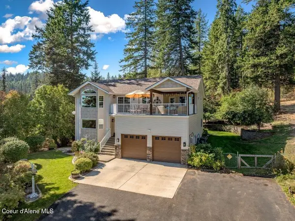 $859,000Active4 beds 3 baths2,792 sq. ft.
11413 N Summit Loop, Hauser, ID 83854
MLS# 26-771Listed by: KELLER WILLIAMS REALTY COEUR D'ALENE
Protect your home and budget from life's surprises with an Assurant Home Warranty, backed by a partner that supports you through every step of homeownership. Explore Plans.
©2026 Century 21 Real Estate LLC. All rights reserved. CENTURY 21®, the CENTURY 21 Logo and C21® are service marks owned by Century 21 Real Estate LLC. Century 21 Real Estate LLC fully supports the principles of the Fair Housing Act and the Equal Opportunity Act. Each office is independently owned and operated. Listing information is deemed reliable but not guaranteed accurate.